NAD 27 and NAD 83 -- You will see these terms when referring to topographic maps of the U.S. NAD 27 refers to North American Datum of 1927. At that time an ellipsoid was established that best defined the shape of North America. All coordinates of latitude and longitude were then established relative to this ellipsoid. Most of the topographic maps of the U.S. are based on the NAD 27 standard.
When computers and satellites came into existence we found we were better able to define the shape of the world. NAD 83 is the new standard that was adopted in 1983.
Below is a copy of the lower right hand corner of a 1:24,000 USGS topographic quadrangle map. This map was updated and printed in 1996. At the time it was updated it had been found that there was a difference between NAD 27 and NAD 83.
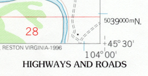
The difference is shown by the + just east of the corner of the map. The corner of the map shows the location of the coordinates based on the NAD 27 standard. The + shows the location of these same coordinates based on the NAD 83 standard. In this case the newer ellipsoid has these coordinates a few 10's of meters east of where it was thought to be based on the NAD 27 standard.
What NAD 83 does is better define the location of all points in North America relative to our system of latitude and longitude.
This becomes an important issue in building databases for Geographic Information Systems. It is most important that the coordinates for all data be based on the same datum. If property boundaries are based on NAD 27 and street intersections are based on NAD 83 coordinates, you can see that there will be some conflicts.